
|
Walking in Derbyshire and the Peak DistrictThe Peak District Walking Festival which is intended as a celebration of the variety of walking opportunities in the Peak District will be held again in 2007. A large variety of ranger and guide led walks are available to suit all abilities and tastes. To order a guide visit www.derbyshire-thepeakdistrict.co.uk Derbyshire, an area of 2631 sq km with a population of around 930000 people, is a county of contrasting scenery which attracted many people even before the creation of the Peak National Park. The history of the region is still much in evidence and routes established by the area's inhabitants in travelling from their farms, churches, mines and markets, remain as a network of footpaths and lanes, offering much enjoyment to today's walkers.
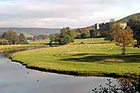
Derbyshire today is perhaps best known for the Peak District
National Park, the first to be designated in Britain, in 1951, in
recognition of its outstanding and largely unspoilt scenery. It
covers 555 square miles of the north of the county, taking in the
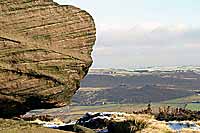
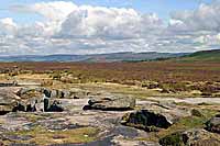
limestone plateau and dales of the White Peak, and the brooding
gritstone moors and edges of the Dark Peak. Over 22 million day
visits are made to the Peak District National Park every year,
making it the second-most visited National Park in the world. The natural beauty of Dovedale and the Manifold Valley alone draw some 2 million visitors with queues forming at the famous stepping stones near the southern end of Dovedale at the busiest times. However avoiding bank holidays and sunny weekends, it is still possible to enjoy a ramble even here in relative peace.
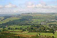
Other areas are less well known and with a planned route, a map, and a pair of walking boots are just as exciting to explore and often far more rewarding. The problem often lies in finding suitable routes.
Derwent Valley Heritage Way was opened in April 2003, a new 55-mile linear walk which runs from Ladybower Reservoir in the north - through some of the area's richest natural landscape and industrial heritage - to Derwent Mouth, where the river Derwent flows into the Trent, in the south. Highlights along the way include the scenic stretch of the river between Hathersage and Grindleford, the Chatsworth Estate, the spectacular limestone cliffs at Matlock Bath and the Derbyshire cradle of the Industrial Revolution, the Derwent Valley Mills World Heritage Site, where the factory system was born. Further south, the riverside path passes through the gentler scenery of Amber Valley to Derby, Elvaston Castle Country Park and the historic inland port of Shardlow on the Trent and Mersey Canal. When it comes to Peak tourist attractions, the phrase 'something for everyone' is fre- quently cited, but in the Derwent Valley Heritage Way's case, it happens to be true. Seasoned ramblers can treat the route as a long distance challenge over several days, staying in local accommodation and using local services along the way. Those who prefer a more leisurely approach can walk individual sections, ranging from just four miles (6.5 km) to seven miles (11.5 km). Some sections are accessible to wheelchair users - such as Ladybower Dam, the Thornhill Trail, Matlock parks such as Hall Leys and Lovers Walk in Matlock Bath, Cromford Canal from Cromford to High Peak Junction and cycle routes in Little Eaton and Derby.
Cyclists are also well catered for, with a
wide variety of terrain to tackle - from the
Upper Derwent Valley, Derwent Reservoirs,
Thornhill Trail and cycle lanes to Hathersage
in the Dark Peak to the High Peak Trail, links
to the Tissington Trail and Carsington Water
in the White Peak. Lower down the Derwent
Valley Heritage Way follows two sections of
the National Cycle Network, in Little Eaton/
Derby and links up with a direct cycle route to
Nottingham. Each stage has been planned
with public transport in mind, so that visitors
can enjoy a linear walk and retum by bus or
train. Many start and end at railway stations,
such as Hathersage, Matlock, Whatstandwell,
Belper and Derby. Regular trains from
Sheffield and Manchester call at Bamford,
Hathersage and Grindleford, while the Derby
to Matlock line serves Duffield, Belper,
Ambergate, Whatstandwell, Cromford and
Matlock Bath. Regular direct bus services
operate to and from Sheffield, Chesterfield,
Manchester, Nottingham and Derby, with
additional routes providing links in stages
between Heatherdene and Bamford in the
north and Shardlow in the south.
More information and a map of the route can be found at Walking The Derwent Valley Heritage Way
The Countryside and Rights of Way Bill of 2000 (CRow) will give you the right to walk across 'access land' in England and Wales. There are clear limitations, however. It only applies to clearly defined mountains, moors, heaths, downs and registered common land. It only applies to walkers and not to cyclists or horse riders. There are exclusions, too - on cultivated land for example. Access land can also be closed off by landowners for up to 28 days a year, and closed for routine management like heather burning, to protect wildlife, for defence reasons and for safety reasons. Significantly, dogs must be kept on leads between 1st March and 31st July and always in the vicinity of livestock. In addition, you can be excluded from grouse moors and fields during lambing if you have a dog. Until access land has been identified and mapped you will still not have the right to roam unless there are existing rights of way. Hopefully his process will be completed as quickly as possible. Ordnance Survey maps showing access land and the countryside bodies will produce information on access opportunities and restrictions. This will be distributed in guides, booklets, leaflets and over the internet. Information will also be available through visitor centres, tourist information offices, local media, shops and at information points near access land.
Wherever you go, please follow the Country Code
See Derbyshire and the Peak District Accommodation for hotels and guest houses in the region.
|
|
| __________________________________________________________________________________________ |
| Homepage Towns and Villages menu Derbyshire Accommodation Local Attractions Events Derbyshire Photographs |